
The Westpark
The Westpark
Location & Connectivity
Line 2A at the end of the street, a proposed Line 6 station drawn on DLF's own master layout, and Infiniti Mall 250 metres away. Every figure on this page carries its source.
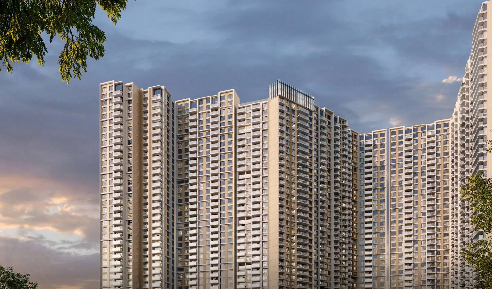
Artist's impression
Oshiwara · Andheri West · Mumbai 400053
The Westpark occupies an Oshiwara estate in Andheri West with its entry and exit on the Jogeshwari–Vikhroli Link Road, one block off New Link Road. That puts an operational metro line at the end of the street, the Western Express Highway a short run east, and the airport inside single-digit kilometres. It also puts the homes on an arterial, which is why every residence is specified with double-glazed windows.
DLF publishes exactly one distance list for The Westpark: the schools, colleges, hospitals, malls and hotels around it. It names no metro station, no railway station, no highway, no sea link and no airport — anywhere on its official site. The developer's entire transit claim is the phrase “seamless connectivity” and a brochure map drawn without a single distance or travel time on it.
So every transit figure below carries the source it came from: measured in a straight line from DLF's own published map pin, agreed between independent property portals, read off DLF's master layout, or reported in the press. A straight line is not a drive. Road distance is always longer, and we have not dressed one up as the other.
Published map pin 19.1438056, 72.8327222
MahaRERA PR1181012500079 (Phase 1) · PR1181012602591 (Phase 1B). Promoter: Pegeen Builders & Developers Pvt. Ltd..
Both links point at the same published coordinates used by the map lower down this page.
0.35 km
Lower Oshiwara metro
Straight line from DLF's map pin · Line 2A, operational
0.25 km
Infiniti Mall, Andheri
DLF's own published list — 250 m
2.5 km
Western Express Highway
Two independent portals agree
6.8 km
CSMIA Terminal 2
Straight line · about 17 min by metro
Sources, left to right: computed from DLF's map pin · DLF's published list · portal consensus · computed plus metro aggregators
The frontage
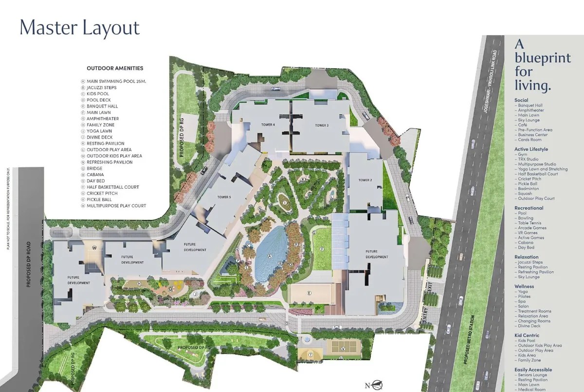
DLF's own master layout answers a question most brochures leave vague: which road you turn onto when you leave home.
Entry and exit are marked on the JVLR side of the plot. Residents join an east–west arterial rather than queuing to merge onto the busiest north–south retail stretch in the suburb.
JVLR runs east to Powai, Vikhroli and the Eastern Express Highway. New Link Road, a block away, runs north and south through Andheri and Goregaon. Two independent arterials is the whole point of this plot.
The same layout prints "PROPOSED METRO STATION" along the Link Road median at the site's edge. It is the only transit marking DLF makes in its own collateral, and it belongs to Metro Line 6.
The layout shows Proposed DP Road along the west and south boundaries, which is why the towers are set back from the carriageway and the Eco-Deck sits inside the ring rather than beside the traffic.
Arterials are loud. The published specification answers that directly — double-glazed windows for sound insulation, with glass balustrades and 6 ft wide balconies kept on the quieter elevations of the plan.
Getting around
Grouped by mode. Where the developer is silent — and on transit it is silent everywhere — the label says who measured it instead.
Line 2A has run elevated along Link Road since January 2023, and two of its stations sit within a kilometre of the site. Line 6 is the one that changes the address: DLF's own master layout prints a proposed metro station on the Link Road median at the site's edge, and that is the single transit claim the developer makes anywhere in its collateral.
Lower Oshiwara — Line 2A (Yellow)
~0.35 km, straight line from the published site pin. Operational since Jan 2023, running elevated along Link Road.
Source · Computed from DLF's map pin
Oshiwara — Line 2A (Yellow)
~0.95 km. The next stop north; portals quote 950 m, which matches.
Source · Computed + portal agreement
Proposed station — Line 6 (Pink)
DLF's own master layout marks a proposed metro station directly alongside the site's Jogeshwari–Vikhroli Link Road frontage. Line 6 runs Swami Samarth Nagar to Vikhroli and is reported over two-thirds complete.
Source · DLF master layout
D N Nagar interchange — Line 1 / Line 2A
~2.1 km. Connects to the Versova–Andheri–Ghatkopar corridor.
Source · Computed from DLF's map pin
Three stations in this pocket carry confusingly similar names — Line 2A's Oshiwara (renamed from Adarsh Nagar), Line 2A's Lower Oshiwara (renamed from Shastri Nagar), and Line 6's own separate Adarsh Nagar. That is where the wide spread in published "nearest metro" figures comes from. Each figure above is measured to the station it names, one station at a time.
DLF's launch release of 25 July 2025 names three roads: the Western Express Highway, S V Road and New Link Road, plus "upcoming developments like the elevated JVLR and Coastal Road". It attaches a distance to none of them. The useful part is the geometry — the Link Road runs north to south through Andheri and Goregaon, the JVLR runs east to Powai, Vikhroli and the Eastern Express Highway, and the site touches both. A bad hour on one is not a bad hour on both.
New Link Road
The project sits effectively on it, with entry and exit off the JVLR frontage.
Source · DLF master layout
Western Express Highway
~2.5 km. Two independent portals agree.
Source · Portal consensus
Versova–Dahisar Coastal Road
A 22 km corridor tying into the Versova–Bandra Sea Link at the Lokhandwala interchange, targeted for completion around 2028.
Source · Press
S V Road runs parallel, between New Link Road and the Western Express Highway. DLF names it but publishes no distance, and the one portal figure we found for it stands alone, so there is no number here. The Versova–Bandra Sea Link is the southbound half of the same coastal story — the Versova–Dahisar corridor is designed to tie into it at the Lokhandwala interchange — but its completion date has moved more than once, so we have not printed one.
The Western Line is still how a large part of Mumbai actually commutes. The two closest platforms here are Ram Mandir and Jogeshwari rather than Andheri, which is the busiest interchange on the line.
Ram Mandir & Jogeshwari (Western Line)
~1.5 km and ~1.7 km, straight line. Andheri is ~3.0 km.
Source · Computed from DLF's map pin
Straight-line again, measured from DLF's published map pin. Reaching a Western Line platform from Oshiwara means crossing east of Link Road, so allow materially more than the figure suggests.
Chhatrapati Shivaji Maharaj International Airport sits to the south-east on DLF's own connectivity map, drawn with an aeroplane glyph and no figure beside it.
Chhatrapati Shivaji Maharaj International Airport
~6.1 km to T1 and ~6.8 km to T2, straight line. By metro, Lower Oshiwara to T2 is about 17 minutes.
Source · Computed + metro aggregators
We publish no drive time to the airport. The portals that do contradict themselves inside a single page — one offers both "within half an hour by car" and a "10–12 minute drive". The metro timing above is the only travel time on this page, and it comes from metro route aggregators, not from DLF.
Bandra Kurla Complex is the office market most Andheri West buyers are heading to. It is close in a straight line and awkward on public transport, because the network does not yet run west to east across this part of the city.
Bandra Kurla Complex
~9.4 km, straight line. DLF's connectivity map places BKC to the south-east but publishes no figure.
Source · Computed from DLF's map pin
DLF's connectivity map places BKC to the south-east and prints no figure for it. Metro Line 6, once it opens, is the piece designed to fix the east–west problem.
The published list
This is the one distance list the developer puts its name to, reproduced as published. Nothing here is computed or inferred by us.
Reproduced from DLF's own nearby-places list. One college appears twice on the developer's version, at two different distances; it is shown once here, at the shorter figure. Distances are the developer's, and the developer does not state whether they are measured by road or in a straight line.
Still being built
Four pieces of infrastructure change how this pocket works. None of them is finished, so each is listed with its status rather than a promise.
Swami Samarth Nagar in Lokhandwala east to Vikhroli, reported over two-thirds complete. It interchanges with Line 7 at the JVLR station and crosses over Line 2A's viaduct near the Infiniti Mall junction. DLF's master layout marks its proposed station directly alongside the site's Link Road frontage.
Source · DLF master layout · published route data
DLF's launch release lists "upcoming developments like the elevated JVLR and Coastal Road" among the reasons it bought here. The project's entry and exit are on that same frontage, so the upgrade lands on the road residents will actually use.
Source · DLF launch release, 25 July 2025
A 22 km corridor tying into the Versova–Bandra Sea Link at the Lokhandwala interchange, targeted for completion around 2028. It is the piece that would reroute southbound traffic off the Western Express Highway.
Source · Press reporting
The southbound half of the same corridor, and the reason the coastal road matters for this address rather than just for Dahisar. Published completion dates have moved more than once, which is why there is no date in this paragraph.
Source · Press reporting · no date published here
Every item above is proposed or under construction. Dates slip, alignments change, and none of this is a commitment by DLF, by the promoter or by us. Buy the home for what already exists — Line 2A running on Link Road, the JVLR frontage, Infiniti Mall at 250 m, Medanta at 1.2 km — and treat the rest as upside.
On the map
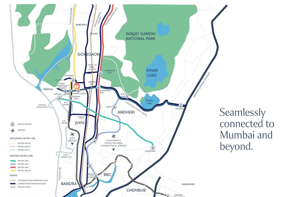
The live map is centred on the published coordinates. The brochure map below it is DLF's own artwork — useful for the lines and the interchanges, and silent on distances.
Oshiwara, Andheri West, Mumbai 40005319.1438056, 72.8327222
View on Google Maps →The legend separates existing Metro Lines 1, 2A, 3 and 7 from upcoming Lines 2B, 6 and 7A, and marks the Versova Connector, the Juhu Connector and the Coastal Road as upcoming road infrastructure. The project pin is the only warm colour on the sheet, sitting just north of the Jogeshwari–Vikhroli Link Road corridor. No travel time and no distance is printed anywhere on it — which is exactly why the figures above are sourced one at a time.
Questions buyers actually ask
Short answers, with the same provenance rules as the rest of the page.
Phase 2 · Towers 6 & 7 · 135 homes
Distances read differently from the pavement than from a table. We will walk you to the Lower Oshiwara station, show you where the proposed Line 6 station sits on the median, and take you through the Phase 2 inventory in Towers 6 and 7 — current price on request.
Mon–Sun · 10am–7pm· Artist's impression