
October 22, 2026
Oshiwara · Andheri West · Location insight
Why Oshiwara Is Changing: Metro Line 6, the Coastal Road and the Link Road Corridor
One metro line already runs past the junction. A second is close. A coastal corridor lands at Lokhandwala later this decade. Here is what is built, what is a target date, and what each one actually changes at street level.
Contents
Oshiwara spent a long time as the part of Andheri West you drove through. It sits on Link Road, with Lokhandwala to the south-west and the Jogeshwari–Vikhroli Link Road running east off it. For most of that time its transport story was a single sentence: everything funnelled on to Link Road, and Link Road funnelled into Andheri.
Three things have changed that sentence. One is finished. One is close. One is a decade-long project with a date that has already moved. Telling them apart is the whole point of this article, because the gap between "operational" and "announced" is where buyers lose money.
The line that already runs
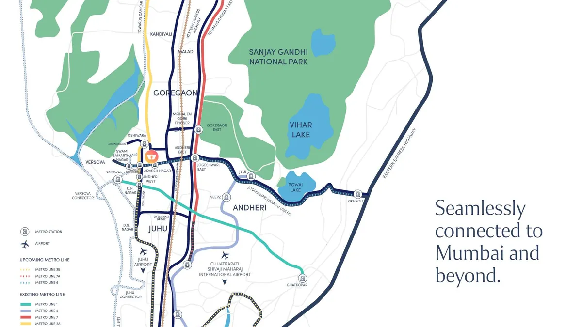
Metro Line 2A — the Yellow Line — runs elevated along Link Road and has been operational since January 2023. It is not a proposal, a phase or a sanction. It is a train that arrives.
Two of its stations sit in this pocket: Lower Oshiwara and Oshiwara. From DLF The Westpark's published map pin, Lower Oshiwara is about 0.35 km in a straight line and Oshiwara about 0.95 km. Those are straight-line measurements against the developer's own coordinates, not walking times — the walk is longer, and anyone quoting you a "two-minute walk" is quoting a straight line with a stopwatch attached to it.
South of here, D N Nagar is about 2.1 km away and interchanges with Line 1, the Versova–Andheri–Ghatkopar corridor. That is the connection that makes Line 2A more than a north–south shuttle: it is how Oshiwara reaches Ghatkopar and the central suburbs without touching a highway.
Every figure above is a straight-line distance computed from DLF's own published map pin, except the Western Express Highway, which is a portal consensus figure. Road distance is always longer than straight line. We label them rather than dress them up as drive times.
Why the figures disagree
Before you compare any two listings in this belt, know where their numbers come from.
DLF publishes no metro, rail or airport distance for The Westpark at all. Every such figure you will see — on a portal, in a brochure, in a WhatsApp forward — is somebody else's measurement, and almost all of them are straight-line distances dressed up as walking or driving times. Road distance is always longer than a straight line, and a straight line does not cross a flyover or wait at a signal.
So we label ours. A figure is either a distance the developer publishes, a straight line computed from the developer's own map coordinates, or a portal consensus number — and we say which. When a listing tells you a project is "two minutes from the metro", ask which station, on which line, measured how, and whether that line is running.
Metro Line 6, the east–west link
Line 6 — the Pink Line — is the one that changes the map, because Mumbai's western suburbs have never had a good east–west rail connection. It runs from Swami Samarth Nagar to Vikhroli, cutting across the island's width rather than along it.
Read that as a commute. Line 2A moves you north and south along Link Road. Line 6 is the leg that goes east, toward the office belts this suburb currently reaches by road — along the Jogeshwari–Vikhroli Link Road, which is also the corridor the line follows.
DLF's own master layout for The Westpark marks a proposed Metro Line 6 station directly alongside the site's Jogeshwari–Vikhroli Link Road frontage. That is the developer's drawing, not a portal's claim, and it is the single strongest connectivity fact about this address.
On status, be careful with numbers. The line is under construction and reported over two-thirds complete. A proposed station and a reported percentage are not the same thing as a running service, and no section of Line 6 is carrying passengers yet. Buy the address, not the opening date.
The Coastal Road, specifically
"The Coastal Road" means two different things depending on who is saying it. The southern section, down in the island city, is open and useful — and it does not touch Andheri West.
What matters here is the northern project: the Versova–Dahisar corridor, about 22 km in total. Its southern end ties into the Versova–Bandra Sea Link at the Lokhandwala interchange — which is the piece that would change southbound travel from Oshiwara, because it bypasses the Link Road entirely.
Completion is targeted around 2028. That is a target reported in the press, not a commitment, and corridors of this size have moved before. Which is the whole discipline of valuing a location: keep two columns, one for what is running and one for what is drawn, and never let the second column price the first.
Link Road at street level
Infrastructure announcements are abstract. Daily life is not, so here is the street-level version of this location.
Infiniti Mall is 250 m away. Lokhandwala Main Street, the nearest real food-and-retail high street, is 1.9 km. Medanta is 1.2 km and Kokilaben Dhirubhai Ambani Hospital 2.2 km — two serious hospitals inside a short drive, which in Mumbai is not a given. Schools run from JBCN at 1.0 km out to Ecole Mondiale at 3.4 km and Oberoi International at 6.2 km. All of those are DLF's own published distances.
Colleges and institutes sit in the same radius — SP Jain Institute of Management Research at 3.1 km, Narsee Monjee College of Commerce & Economics at 4.7 km — which is part of why this pocket carries a daytime population as well as a residential one, and why the retail on Link Road sustains itself.
For the airport, DLF publishes no figure at all. Straight-line, Terminal 1 is about 6.1 km and Terminal 2 about 6.8 km from the site pin; metro aggregators put Lower Oshiwara to T2 at roughly 17 minutes of travel time. Bandra Kurla Complex is about 9.4 km in a straight line.
What it means for value
Honestly: less than the headlines suggest, and more than the sceptics allow.
We are not going to quote you a per-square-foot rate for Andheri West, and you should be wary of anyone who does without saying where it came from. Portal rates are asking rates set by third-party sellers, not transaction prices; no two series agree with each other; and most of them do not even state whether the rate is on carpet or on a marketed area, which can move the same number by a fifth. DLF publishes no price list for The Westpark, so an indicative position — ₹5.5 Cr onwards — and a quote against a specific tower, floor and facing is the only honest way to answer the question.
What you can price with some confidence is the infrastructure, and only in the right order. One metro line already runs past this junction, which is a fact you can test by walking to it. A second is under construction, reported over two-thirds complete, with a station drawn on the developer's own master layout at the site's frontage — credible, unopened. The coastal corridor is targeted for late in the decade.
Price the first. Discount the second. Treat the third as upside, and do not pay today for a road that opens in 2028.
Is Metro Line 6 open?▾
Which metro station is closest to DLF The Westpark?▾
Does the Coastal Road serve Andheri West today?▾
Why do metro distances for Oshiwara vary so much between websites?▾
What transit does The Westpark actually have today?▾
See the corridor on the project map
Every distance we publish for The Westpark is labelled with where it came from — developer, computed, or portal.
Location & connectivity ↗